

Showing posts with label Weather. Show all posts
Showing posts with label Weather. Show all posts
Wednesday, 29 July 2026

Saturday, 11 July 2026
UK Weather Forecast 200-Mile Rain Bomb
UK weather forecast as 200-mile rain bomb set to soak 25 counties - full list

Story by
Britain is enjoying its third heatwave of the year as temperatures rocket beyond 30C. But this scorching spell could come to a sudden halt as a 200-mile deluge prepares to strike.
Fresh weather maps from WXCharts, using MetDesk data, show that changeable conditions may return next weekend, delivering rainfall across 25 counties. One massive band of rain on July 19 (next Sunday) is predicted to stretch from Cumbria in North West England all the way to Northamptonshire in the East Midlands - an enormous 220 miles.
Meanwhile, the East of England is also set for heavy showers, with Suffolk expected to receive up to 7.5mm/hr next Sunday. The Met Office has issued warnings about potential thunderstorms from mid-July, with increasingly volatile weather possibly ahead.
Its outlook for July 15 to 24 states: "High pressure to the northeast of the UK with low pressure over the Bay of Biscay starts the period with broadly settled weather for the north of the UK with a risk of thunderstorms into the south of the UK from France at times".
"Through the weekend potentially turning more unsettled from the south before more settled conditions arrive from the west. Uncertain into the next week as cloud and longer spells of rain threaten the NW and possibly running through the UK at times.", reports the Express.
"Temperatures will be warm or very warm initially, perhaps hot at times in the southwest, likely easing to warm or near average over the weekend, though further hot spells possible especially in the south."
Counties anticipating rainfall:
- Devon
- Dorset
- London
- Surrey
- Suffolk
- Norfolk
- Essex
- Lincolnshire
- Cambridgeshire
- Northamptonshire
- Warwickshire
- Worcestershire
- Herefordshire
- Shropshire
- Cheshire
- Merseyside
- Lancashire
- Cumbria
- Nottinghamshire
- Derbyshire
- Rutland
- Leicestershire
- Durham
- Hertfordshire
- Buckinghamshire

Weather Forecast for Sutton Surrey
Monday, 22 June 2026
Amber Weather Warning This Week


If you do go out make sure you apply sun protection and it's essential to keep hydrated during this week.
Wednesday, 2 October 2024
It's Going To Be A Cold October

As the cost of energy has increased and the pensioners winter heating allowance is being removed, it is reported that Low pressure from the Atlantic is set to arrive on October 11 and into the weekend bringing areas of cold rain.
The weekend of October 12 to 13 is forecast to see "a mixture of unsettled showery spells and longer periods of rain is most likely", however, there will be "some brighter spells with the driest weather in the south", which is good for me. I don't mind cold and dry, but I can't get on with much on the allotment if its wet.
WXCHARTS predicts that large areas of Scotland will see the worst of the freezing conditions on October 13 with thermometers to drop as low as -2C to -4C in many areas.
It's been noticeably colder the last couple of days and this morning my central heating turned itself on.
Tuesday, 24 September 2024
Tree Surgeon "Would You Like Some Woodchips?"

With all the rain and flooding caused by the mega-storm that has been dumping an Months worth of rain in a day over the weekend & Monday and knowing that Mill Green was flooded and two cars stranded on Sunday and still not moved Monday I have not been down to the allotment. John showed me photos of his plot that had 75mm - 100mm of water in places, he dug some drainage channels into the vacant Japanese's Knotweed plot to help spread the load.
My local tree surgeon rang to ask if we needed topping up with woodchip as he was working near to our allotment site and had a full lorry load. It had stopped raining and was bright so I went to the allotment mid afternoon to meet him there and open the gate and let him in to unload.

We were getting to the end of the good path quality woodchip pile, and whilst waiting for the tree surgeon to arrive I filled two wheel barrow loads and five square flower buckets worth of woodchip.

Then I set about laying new woodchips on one of the paths between beds up on plot 1A.

I'm really happy with how the potting shed is looking now the wood stain has dried. I'm just hoping for a few dry days above 10C so I can finish off the first coat to those areas I have not managed to paint yet.

The plot name and number sign has really weathered over the last 18 months, but when I painted the shed I made sure I gave the sign a good first coat especially on the end grain where the varnish used had weathered badly. I like the weathered patina look that the sign has around the edges and hopefully the V33 will maintain that look and not let the sign weather too much more.
The temporary panel under the sign needs replacing, but that will also allow access to paint around the window frame and flashings.
Sunday, 8 September 2024

Monday, 24 June 2024
A Yellow Heat Health Alert

A yellow heat health alert has been issued for most of England as temperatures are set to hit 30C in parts of the country.
The notification, covering all but one region of the country, highlights the risk of increased pressure on healthcare services as a result of the forecast mini-heatwave.
The alert, issued jointly by the UK Health Security Agency (UKHSA) and Met Office, comes into force from Monday morning and remains in place until late Thursday afternoon.
Temperatures are expected to spike at 30C (86F) in parts over the coming days, with "many places" due to see the thermometer reach the mid-20Cs (77F).
See the latest weather forecast where you are
This is the forecast for my neck of the woods for the next couple of weeks

The strongest warnings have been given for the East Midlands, the East of England, East Anglia and the South East with the "potential for significant impacts to be observed across the health and social care sector due to the high temperatures".
These include an "observed increase in mortality across the population likely, particularly in the 65+ age group or those with health conditions, but impacts may also be seen in younger age groups".
For the North West and North East of England, the West of England, the South West and London, there is an "increase in risk of mortality amongst vulnerable individual and increased potential for indoor environments to become very warm", the alerts warn.
The heat health alert service covers England only, with colours including green (meaning no alert is issued); yellow (meaning a response is required); amber (an enhanced response is required); and red (an emergency response) which would indicate a significant risk to life.
The upcoming hot spell marks a break from the rainy spring, which saw 32% more rainfall than the average in England and Wales, making it the fifth wettest for England and the eighth wettest recorded for Wales, according to the Met Office.
However, the heat is only expected to last until midweek, giving way to showers, thunderstorms and persistent rain.
The wet weather has been coming from the Atlantic and a high-pressure system is expected to halt it for a few days.
Met Office operational meteorologist Honor Criswick said: "As we're pushing into next week, we're starting to see the hotter spells, but it is going to be quite brief."
Despite the wet weather, it has been the warmest May and spring ever recorded in the UK.
The average temperature has been 13.1C, beating the previous 2008 record of 12.1C.
Dan Rudman, Met Office deputy chief meteorologist, said: "Whether or not everyone experiences heatwave thresholds, the majority of the UK will experience the highest temperatures so far this year.
"Confidence in the forecast reduces markedly from Wednesday onwards, with uncertainty in both how long the heat will last and how it will break down, which we will be keeping an eye on for the coming days.
"However, by next weekend, cooler, changeable conditions become more likely."
Monday, 6 March 2023
Freezing Artic Blast

They have been on about this for a few weeks now, above is what's hit my newsfeed in the last few days. First it was going to be the first week of March and now its the second, and with each post the prediction of snow reaches further and further down the county.
I know how cold it was on the plot yesterday, with rain forecast for today, I'm staying in doors and assembling my second Loft Conversion for my Plot 1A Greenhouse now that the solar powered twin fans have arrived.
Update


Snow and ice will blanket the country for the next five days as cold Arctic air sweeps in from the north, temperatures as low as -10C threaten travel disruption and power cuts.

Sunday, 4 December 2022
It's Getting Colder
Well with both of my daughters out for the day, there was no real chance of getting down to the allotment today, so I finished off another 9 Self watering Pop Bottles, watched a film "Christmas With You" with my good lady wife in Netflix, and I had to say I did enjoy it.
When I have ventured out of the house to go to the greenhouse of the car to load it up ready for my next trip to the allotment it has been bitter, and I can believe the headlines coming into my news feed during the day.


Looking at one of my weather apps Ventusky, it looks like it's mainly going to be Scotland the Midlands and Wales that will get hit first and we may see some snow on the 14th December.

Wednesday, 30 November 2022
Beast from the East 2022 On It's Way
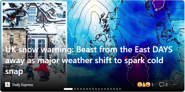
One thing is sure, that the temperatures have dropped over the last few days, and it feels like the warnings could be right even though it is the Daily Express.

More and more warnings dropping into my news feed, and it's feeling a lot colder out there this afternoon. let's take a look at the weather forecast ...
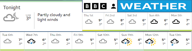
Looking like cold possibly frosty weather (3C and below) from the 6th December onwards. I don't mind cold days on the allotment, but I can't be doing wet, and I still have so much to get done on the plot before the next growing season kicks off in 2023.
Friday, 18 February 2022
Met Office Red Warning

“The red warning areas indicate a significant danger to life as extremely strong winds provide the potential for damage to structures and flying debris. Although the most exposed coastal areas could see gusts in excess of 90mph, winds will remain notably strong further inland, with gusts of between 60-70mph for most within the amber warning area, and up to 80mph in a few places.”
Katharine Smith, Environment Agency Flood Duty Manager, said: “Strong winds could bring coastal flooding to parts of the west, southwest and south coast of England, as well as the tidal River Severn, in the early hours of Friday morning. This is due to Storm Eunice resulting in high waves and potential storm surge coinciding with the start of a period of spring tides.
Thursday, 17 February 2022
Storm Eunice Is On it's Way

Using Ventusky Watch the Wind and taking a peek at what we are likely to see tomorrow during the day, and wondering how things down the allotment will or will not stand up to it and how much damage we may encounter. Picture above is at 13:00 or 1pm when the winds in Sutton is predicted to be 127 km/h

Picture above is at 15:00 or 3pm where the wind speed in Sutton is predicted in the 130 - 140 km/h zone at 136 km/h

Picture above at at 20:00 or 8pm and the worse of the Storm Eunice is over for the South East if England.
Friday, 19 November 2021
Snow Fear Of Snow On The Plot
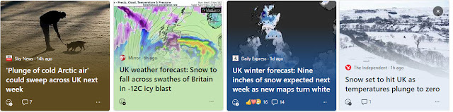
My newsfeed has been warning me for some time about an artic
wind and the possibility of snow over the UK, first it was anticipated and reported to take
place on the weekend of the 13th & 14th of November,
which didn’t happen and in fact, I was on the plot on Sunday the 14th November in a tee shirt with a fleece tied around my waist to keep my back warm as we
worked, it was quite sunny and warmish for the time of year.
Now the warnings to Brits of freezing temperatures and heavy snow
to fall across swathes of the country from next week keep popping up but they are other news media just regurgitating the Express post.
The Met Office has updated its forecast for next week and warned
“snow likely across higher ground and possibly falling to low levels at
times"., telling the Express newspaper that temperatures could fall by 10
degrees after 7C-10C highs at the weekend.
This information is based on WXCharts maps are showing snow
first hitting the north of the UK and then moving south over the following
couple of days.
After a largely mild November, the cold weather is set to come from Arctic winds which will bring freezing temperatures and has slashed odds on it becoming the coldest November on record and the betting odds have been slashed.
Temperatures could be around zero or 1C in parts of the country Monday 1st December, WXCharts maps suggest.
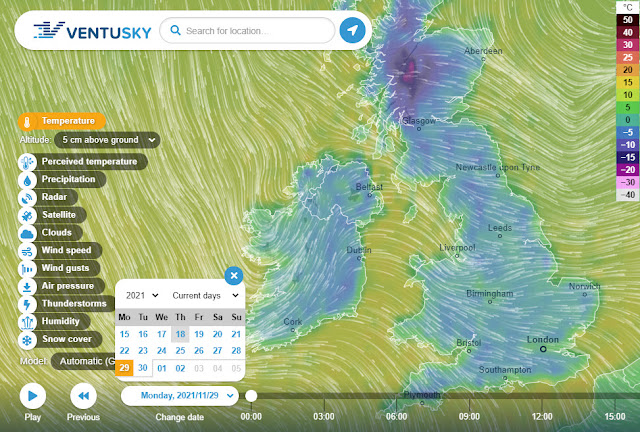
I had not heard of WXCharts but have heard of and my go to app is Ventusky so I've taken a look at the snow possibility on that, and this is what I have found.
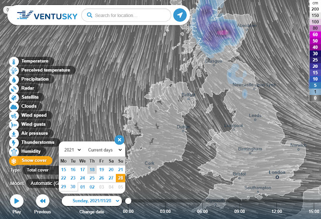
Looks like snow is going to hit Scotland on Sunday 28th November
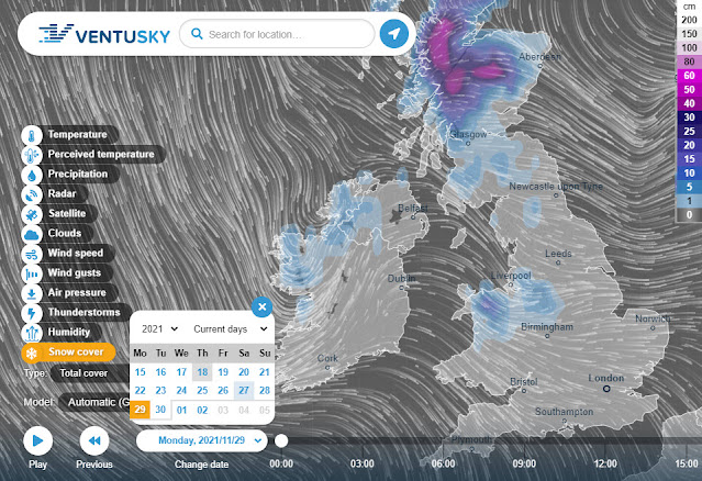
Getting thick in the highlands of Scotland, moving into Ireland and Mid West UK on Monday.
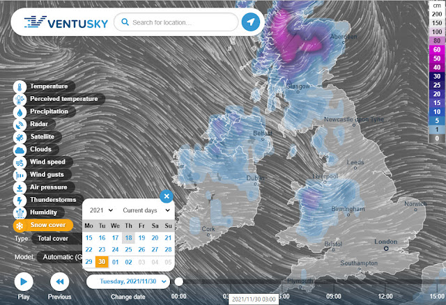
Sweeping down into Wales Tuesday 30th November
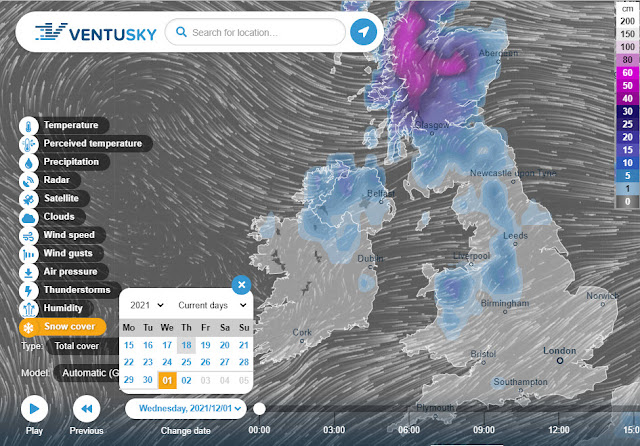
1st Dec looking like the worst of the snow may be over and receding in England.
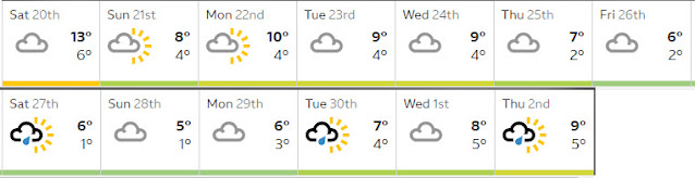
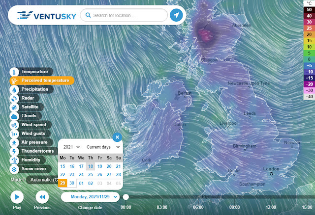
Looking at the Weather based on the Allotment Postcode looks like coldest days will be Saturday 27th & Sunday 28th November. Ventusky is showing some really cold weather in Scotland and the rest of the UK
The Perceived Temperatures with the wind chill factor don't look good at all !
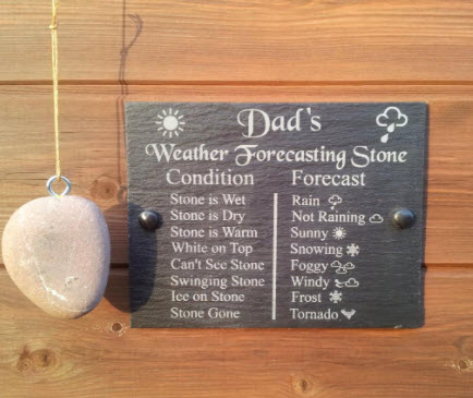
At the end of the day we will just have to wait and see, and use Dads Weather Stone.
Wednesday, 29 September 2021
More Conventional Autumn?

Following yesterdays headlines, and the thunder & lightning and heavy rain last night, today the Daily Express says "Mountain hikers in Scotland are battling against harsher winds and blizzards, while much of the UK has seen a drastic drop from the unseasonably balmy September. It comes as meteorologists suggest a cold front will strike the UK as October begins, bringing a more conventional autumn."
There has been a noticeable drop in temperatures as the Indian Summer has come to an end. Looking forward a little

I had planned a visit to the allotment on Saturday this week as I could not arrange cover for my wife on Sunday, but looking at the weather it may just be a swift visit to the greenhouse to water and harvest tomatoes. At the moment at least the weekend of the 9th & 10 October is looking good.
Thursday, 2 September 2021
Indian Summer ?


Next Mondays temperatures based on the current model outputs. It's looking likely that we'll see warmer temperatures initially on Sunday across southern England, then warmer temperatures moving further north through Monday and Tuesday.
The big uncertainty comes after Tuesday, whether or not the Atlantic is knocking on our door and how quick the warmer air breaks down.
At least we have a chance of some sunshine and warmer temperatures before Autumn really does make an appearance?
Monday, 9 August 2021
Strange Weather.

Climate change is a real thing, we gardeners have seen the changes in the weather and the seasons over the years. So much rain again this year that once again the grotto canal in Carshalton Park is starting to fill with water, as the water table once again rises up above the invert of the canal.
If we go back 5 days, it was not supposed to rain today and now it's supposed to rain all day, so for me that means an early shopping trip to my local supermarket today and then if the forecast is to be believed we should have 12 days of sun and temperatures in the low 20's which will allow me hopefully if my daughter is not dragged back into her office to work, some time to get down on the plot and on top of the weeds that have been having a field day.
Recovery of a work load following lockdown has been slow, many enquires but few jobs that I can take on due to the restrictions of being a carer and having to fix site visits in around the daily support provided. My radius of operation has reduced dramatically, and I'm no longer happy with travelling into London on the tube due to the pandemic and the risks that are still out there as the government isn't really following the science anymore and is just looking for economic recovery at any cost.
I'm working my way from semi retirement slowly towards total retirement, and hopefully get to enjoy it for sometime before moving to a plot in the great allotment in the sky.
Friday, 22 January 2021
Storm Christoph

Three days of rain has brought flooding across large parts of Wales The Met Office said over the past two days Wales had the highest rainfall of the four UK nations.
Between 19 and 21 January, Aberllefenni in Gwynedd saw 188mm (7.5in) of rain, more than average rainfall for Wales for the whole of January, which is 156.89mm (63in).

That was followed by 180mm (7in) in Crai reservoir, Powys, 169.8mm (6.6in) in Treherbert, Rhondda Cynon Taf, and 166mm (6.5in) in both Maerdy, RCT, and Capel Curig, Conwy.
About 2,000 homes in the Didsbury and Northendean areas of Manchester, Ruthin and Bangor-on-Dee, North Wales and Maghull, Merseyside, were also affected overnight.
People have been told Covid rules let them leave their homes in an emergency.
One hundred homes are also being evacuated in Skewen, near Neath in West Glamorgan, because of flooding related to mine works, authorities say.
Severe flood warnings remain in place, and further rain is expected next week.
There have been many photos of plots that have been flooded and the normal questions of what can be done about it. The usual suggestions of adding drainage or using raised beds depending on the severity shown in the photo, or the suggestion of growing rice.
Locally London Borough of Sutton its been high winds, rain and a very hard frost overnight but there is this big yellow ball in the sky this morning, that we have not seen for a while.
Friday, 2 October 2020
Batten Down The Hatches Troops.

Wednesday, 17 June 2020
Thunderstorms and Heavy Rain Hit the UK

Heavy downpours and violent thunderstorms battered the UK this afternoon, with forecasters warning of further rain to come.
The Met Office issued warnings for thunderstorms across large parts of the UK today, with heavy downpours that caused flooding and disruption in places.
A warning is also in place for rain in the south on Thursday. Some areas could see heavy rainfall of 50mm in just a few hours, the Met Office warned.
“Although some places will miss these heavy showers and thunderstorms, where they do occur they’ll be quite lively, bringing torrential downpours with 25 to 35mm rain falling in an hour and a few places seeing perhaps 40 to 50mm rain in a couple of hours," Met Office Chief Meteorologist Neil Armstrong said.
Subscribe to:
Posts (Atom)